Ancestral Roofs

"In Praise of Older Buildings"

Thursday, November 30, 2017

Go north, young man

broken dreams, westward along the Monck Road
I fell under the spell of the Old Hastings Road last fall. It's a place humming with old voices, ambitions, tragedy. I wrote about the road here and on my return the following week, last fall.

I posted  about a sister scheme, the Frontenac Road in a post some time ago.

The Colonization road scheme always infuriates me. Can't know, wasn't there, but I suspect it wasn't unbridled optimism in the potential of the north and a fervent desire to see the little guy get ahead, as much as cynical manipulation by  land agents in the 1850s, that led to the surveying and granting of marginal swamp and rock to desperate settlers hoping to make a future. It served some other purpose than altruism. Nation-building by distributing population northward? Stepping stones for the lumbering industry's march northward, little farms available to provide food and labour to the massive logging operations harvesting the thin soil's only crop?

Many have quoted C.F. Aylsworth , Ontario Land Surveyor, who described the Hastings Road in 1925 as "one long, long trail of abandoned farms, adversity, blasted hopes, broken hearts and exhausted ambition."


I spent a while in Bancroft and Maynooth last year, learning more about two more colonization roads, the Monck Road and the Peterson Road. (Gerry Boyce in Historic Hastings relates stories of  the Ottawa, Opeongo, Addington and Mississippi Roads as well.)

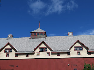
This squared timber building once sat eight miles east of town, HQ for the Bronson&Weston lumber company. Now it serves as Bancroft's museum and visitor centre.

an echo of  yesterday's limitless white pine forests
Outside is an OHT plaque telling the Monck Road story:
"This road was constructed for the dual purpose of opening up a wilderness area to settlement and providing an alternative, less vulnerable military route between the upper Great Lakes and the Ottawa valley. Its line from the vicinity of Lake Couchiching to the junction of the Hastings and Mississippi Colonization Roads at the hamlet of York River (now Bancroft) was surveyed in 1864-5 at the time of the American Civil War. Named in honour of the Governor General (1861-1868) Lord Monck, construction was begun in 1866 and completed in 1873, Free grants of land along its route were made to persons fulfilling the required settlement duties."

Indulge me in a bit of petulance about how decisions about the development of this country, the use of its resources and the fate of its people, were in the hands of an absentee landlord of sorts, a  British lord, top of the pecking order of privileged oligarchs who intended to recreate the English system of class and privilege in the colonies . How much did he know or care about the fate of the folks to whom he granted 'free' land?

No wonder Upper and Lower Canada's stories are filled with rebellions for democratic reform. I would have been hung.
towards the Peterson road turn


Later on and further north, at Maynooth (formerly Doyle's Corners) I read another plaque, this time,  about the Peterson Road:
"The Peterson Road was named after surveyor Joseph S. Peterson who determined its route in this region. Constructed 1858-1863 at a cost of some $39,000 it stretched  about 114 miles between the Muskoka and Opeongo Roads and formed part of a system of government colonization routes built to open up the southern region of the Precambrian Shield. Poor soil disappointed hopes of large-scale agricultural settlement along this road both on government "free grant" lots and on the land of the Canadian Land and Emigration Company. Though portions of the route were overgrown by the 1870s, the Maynooth-Combermere section aided lumbering and now contributes to the development of an important Ontario vacation area."

looking east torward Combermere, the road still travelled
Little Maynooth is doing alright.


Jane Urquhart's Away is a stunning novel which captures the colonization road settler's experience - the desperate hope, spirit-crushing privation, soul-destroying labour, and the madness born of isolation. It's a favourite I return to time and time again. There's a heart-breaking scene when the son of an Irish famine migrant free grant-holder realizes that the small holding and the future he hoped for it, is built on solid rock.


Liam seeks out the failed bush school of his dead father, to find a rotting copy of the Canadian Geological Survey. He locates his farm north of Moira Lake on the map, "noting that the shading of the map had changed from a dot to a slanted line pattern...According to the words at the bottom of the page, this vast territory was called the Canadian Shield. It covered hundreds of thousands of square miles. There were no pauses in its pervasiveness, no exceptions to its continuity. It had been put there by an ice age that would never happen again, it would be there for all time, and it was made of solid rock."

Wednesday, November 29, 2017

Cover Girl

Since LOML and I visited Unionville a couple of weeks ago, I have posted once, and been working on a couple of draft posts, based on the intense connection I formed with the village. From a municipal perspective, Unionville, once a self-sufficient rural village, is now a suburban village in the City of Markham.

It is designated a Heritage Conservation District. Its historic buildings, streetscapes and character are under tremendous pressure from the city growing around it. I have been reading a document titled The Community Vision Plan for Main Street Unionville, a thoughtful response to the threats and opportunities of change.


I will leave those challenges to those wiser than I, and delight in the heritage character which was recognized early (1970s) and has been preserved in large measure. The neighbourhood south of the Toronto and Nipissing Railway (1871-1882) tracks is a long tree-lined residential block of intact heritage properties, which made for a delightful walk on the day of our visit.


What made the walk even more delightful (as I had been unable to find a downloadable, printable, foldable companion to advise my steps) was to find the book Historic Unionville online when I returned to my study - it wasn't long (measured in seconds) until I had it on order. I cannot say enough about George Duncan, the local history/family research and architectural history knowledge packed into this slim volume is astonishing. He was the man for the job; George Duncan was Markham's senior heritage planner..

This exquisite house is the cover photo for George Duncan's book, and a worthy choice too. This is the William Eckardt House (a significant name in this town) built around 1856, by the son of the operator of the family sawmill. William saw a great future for the village, and subdivided part of his farm (the other delicious old homes along Main Street sprang from his good idea) and benefitted even further when the railway came to town, across his land.

Unionville owes plenty to William Eckardt's vision and hard work.


William's house is a beauty, one which reminds us that appreciating early homes goes deeper than 'what style is this house?' For this Classic Ontario Farmhouse (I love that Duncan uses Marion MacRae's term for this form) with its Gothic Revival gable window with delicate tracery (love the winged shutters,) tall Regency casement windows, a sturdy doorcase with rectangular transom and Regency rectilinear glazing pattern is a delightful combination of the best of several stylistic influences.

Light and shadow from the mature trees, wide lawns and meticulous maintenance play their part. From the book I learned that the house was originally red brick with buff brick quoins and window trims, once sported curvy Gothic Revival bargeboard, and a Regency bellcast verandah with fretsawn brackets. You think you know somebody, right?

Monday, November 27, 2017

Urban Country

One of my Ottawa junkets this past summer took me to a place I had never visited, not in all the years I lived in the city, not even when I skirted its perimeter in the Arboretum near Hartwell's Locks so often during my Carleton University days.

I was expecting a quiet, studious sort of place. Stuffy research into grain varieties, inquiries into milk yield. Monograph-producing government agricultural scientists. I was astonished to arrive at the already filling parking lot at 10 in the morning, to join the crowds trudging towards the entrance.
  Groups of daycare and school trip kids, in colour-matched teeshirts to reassure their minders. The little princes and princesses clutching their walking ropes, all trending upwards towards the experience of farm. Smells and sounds of cattle, goats, pigs. Dairy Disney.

Impressive farm buildings of the early twentieth century. Okay, maybe I was the only one noticing those. But the buildings of Ottawa's Central Experimental Farm (CEF) are impressive, to be sure. 

I was instantly drawn to this fascinating structure on a height of land above the barnyard and kiddie attractions. This is 'the Cereal Building,' the Farm's centre for grain research, and a heavy hitter from 1900 - 1930 developing viable new strains of wheat for the Canadian producer.

The barn was built in 1915-16 and is one of the farm's "best preserved examples of a Shingle style building, featuring board and batten siding with shingles above." (quoted from the plaque beside the massive barn doors, which, sadly were closed to the non-scientific set.) Loved the sash windows, shed dormer, slightly belled second storey (a hint of medieval jetty?) and painted trim suggesting half-timbering.

of course her name is Kahlua
The Heritage Character statement advises that the barn is "a pleasing and competent iteration of the shingle and board and batten vocabulary established for the farm by the great barn..." and cautions against any unsympathetic modernization.

Next came the Canada Agriculture and Food Museum (which made canola exciting!) and the Dairy barn - at the other end of building.  It was fun to wander into the barns, the sounds and smells so familiar I almost expected to look out the open doors to the familiar territory of our farm, or those of the Uncles.


All of the buildings are styled with Period Revival elements, and I noted what I consider to be some fine Arts and Crafts embellishments here and there. Truly lovely structures to wander among.
huggable Star

 Shingles, board and batten, sash windows, paint colours, trims. Love the shingled silo nestled in the corner. A panel in the dairy barn states that dairy cows have been raised and milked here since the 1890s. This barn was destroyed by fire in 1913, and rebuilt using the original plans, on the same site, the following year. Farmers do that.


 In some areas, visiting kids (and I suppose I could have asked) got to cuddle with the animals. I was astonished to see the gate to the goat pen open, and a group of kids herded in. Goats seemed happy of the attention. It was amazing to see the different way each child interacted.


#55 Horticulture Building


Just outside the perimeter of the visitor attraction area, stood these two period revival style office buildings, sentimentally named Buildings #55 (Horticulture Building  and #57 (Dairy Technology Building.) The facades are unchanged since their construction in 1936. The heritage statement cites Queen Anne and Tudor Revival stylistic inspiration.


#57 Dairy Technology Building
Okay, readers (those intrepid souls still following along) this is the moment where I remind you that this blog started as a research tool for me. What follows is my shopping list for next visit, a list of links to 'the ones that got away.' Feel free to skip over this bit.

The 1935 William Saunders building

Horticulture building, built 1924

Heritage house, Building 54


Building #94

ARC Biotech Building No. 34

Romanesque Revival Dominion Observatory and Photo Equatorial Building

Building 60 and Historic Places listing
Building 2, Observatory House (1909).

Main Dairy Barn along Carling Avenue (boy I bet those developers twitch when they drive by the open farmland here.

Carpenter's Shop. Who knew?

(And should I need more architectural diversion on my next Ottawa trip, I'll save Wikipedia's Canadian Register of Historic Places list. Here's a handy CEF map.)

All CEF structures are carefully documented, with FHBRO (Federal Heritage Buildings Review Office) credentials, Heritage Character Statements and DFRP numbers. These folks are not fooling around. This IS Ottawa, after all.

more # 94
Above beyond the pointy fenceposts and pavement is  Building #94, reinvented in 2015, evolving from the former Machine Building into "one of the newest and most imaginative

Didn't go in. That's about the moment when I spotted the goat enclosure.


For all that this is a fascinating field trip, it is a serious science/heritage destination (here's lots more info on Wiki.)  Should that escape the visitor, the fact that the Central Experimental Farm is designated a National Historic Site may carry weight. It was designated in 1997 because of its huge significance as a cultural landscape, a farm within a city, and the source of important Agri-Food scientific discovery over its lifetime.

The National Historic Site management plan  makes me think of Unionville's thoughtful process, striving to balance growth and development with the growing demand for heritage preservation - and people's need for - historic neighbourhoods, buildings...and farms.

Nice to know that these fuzzy fellows have friends; the group Friends of the Farm will be more and more important as years, and development demands advance. The past few years there has been tension, shall we say, about the site of the Ottawa Civic Hospital expansion, which has set its sights on a site on the farm. 

Wednesday, November 22, 2017

The Little House

47 Earl Street (1841)
My favourite house styles were once the high Victorian excesses - the more the merrier -  Queen Anne peekaboo verandahs, brooding Romanesque arcades, high-flying Gothic tracery.

Now, I am drawn to the simple serenity of early homes. I spotted a couple of them during a Kingston walkabout some time ago.


By way of cleansing the palate, after thinking about High Victorians for the last while, I offer this collection of simple, serene, unpretentious early homes.

232 King Street (pre 1820)
The frame home above was built as a boarding house. It's now covered with stucco, and beautifully kept, with its plain neat garden fence. I love the top left window - hardly enough space for it. Wonder what the story was? This house  makes me think of Lawren Harris' early Toronto house paintings - which I adore.


Here's another frame house covered in stucco, a rarity in this brick and stone neighbourhood. The Register of Historic Places is very excited about this "unique and important element in the streetscape", as it has a  rare brick and stone Victorian coach house behind it. The home's tight-to-the-sidewalk placement and its narrowness compared to its width, earmark it as early. Documents suggest the house might be as early as 1812. The dry-dock Davis family lived in this double house.

I love the simple 'eared' wooden window surrounds, the deepset double doorway with the scrollwork trimmed doors, described as Victorian (that's a wide date range, folks). The Register reports many of the windows are original. I love the green bit with trees in front, and the way it stands separate from later buildings on either side. Respect for the old ones.


This small red brick Georgian double house is best seen in company with its neighbours, which you can do via this super Googlemaps  panorama. The designation plaque tells us it was built in 1868. Haven't found any other info. The 1843 limestone two storey structure to the right has a lovely inviting carriage-way to the back. Flowers everywhere. A vast improvement over the days when the courtyard was home to the family's horses.

This little store completes the King Street grouping. It was built originally as a house (1833) but changed over to a store by 1850. 
A house doesn't have to be huge to be grand.
Lawren Harris knew that.


Tuesday, November 21, 2017

Beveridge, anyone? Tay, perhaps?

lockmaster's house
Forgive me. Can't help it, I am still wandering canal-side. Today's sharp cold wind makes the prospect of a virtual amble in this bucolic bit of Ontario all the more appealing. In July I spent an afternoon at Beveridge Locks near Perth, a stop off the road back to camp.

We're not on the Rideau anymore, Dorothy, but along a boondoggle called the Tay Canal. I'll try to distill the story from the wealth of Perth and District heritage sources. It's the story of Perth entrepreneurs who created a water link between their town (and their industries) on the Tay River and the Rideau Canal and the wider world of outside markets in the 1800s.

A first canal (I'll omit description of the gargantuan physical labours of the builders, and the  financial and political machinations of the Tay Navigation Company) connected Perth with Port Elmsley, the gateway to the Rideau.) A later 10km iteration joined Perth and Beveridge Bay by the 1880s. Not without controversy. Now it's the serene recreational boat passage I show you here, part of the UNESCO World Heritage Site Rideau canal system.


Ample information about Beveridge Lockstation (this one is the lower of the two, it turns out) and all the other wonderful spots I've been collecting, is ready to hand on the Rideau Canal World Heritage Site site. If you think you might like to venture canalside, this appears to be a handy guide. But nowhere can I find any history of the buildings of Beveridges. Love the tiny gambrel roof shed, and would like to know its story.


A fascinating part of the story is the role of 'The Haggarts.' An OHT plaque on a quiet waterside street in Perth conjures the industrial power of the town, and the family, in the nineteenth century.

John Haggart, Scottish stonemason, came to Perth in 1832,  purchased and expanded the settlement's first (1817) mill and mill dam, and built this exquisite Regency stucco over stone house on the property in 1837.

Here's what HistoricPlaces.ca has to say about the home, still in the perfect Regency setting of trees, sloping lawns and a wild ravine, a view of the lagoon behind a rustic stone fence.

In 1854  18-year old lawyer son John Graham Haggart inherited house, property, mills. John Jr. was a controversial character, politician (over his career he served as mayor, MP, Post-Master General, Minister of Railways and Canals, leader of the Ontario Conservatives and top contender for party leadership,) and mill-owner.

Did we mention... a man who got things done? One of the things John got done was that canal leading to his mill complex, and the turning lagoon at Tay Basin.

There was comment. The canal proved awkward, acquiring the name 'Haggart's Ditch.' Finally, the government of the day intervened. Sir John A. commented that the project draining the county also "drains the public treasury pretty well."

And as it served Haggart and his enterprises, it serves us well too. A green and lovely spot in which to contemplate Perth's industrial past. And the empire builders who brought it into being.