Ancestral Roofs

"In Praise of Older Buildings"

Monday, November 21, 2016

Barn Dance

Country roads are faster than they used to be.

I can recall mom or dad commenting in their peculiar patois, when someone would hurtle past our farm on the gravel road - "he's (because it would always be a guy) just siftin."

The felon was likely doing about 50mph, but it looked fast in the day.

 Last Friday I travelled a route Den and I had taken on a return from Peterborough, visiting Wooler, Warkworth and Hastings.

My quest was to absorb as much sun, fresh air, warmth and peace as I could pack into one day, to take every less travelled road, and to spend time with dying and dead farms and their buildings.

 Easily done. But for one thing. Parking.

Farms are often helpful,  a culvert at the entrance to an unused laneway providing a safe spot to stow a small car. The faster bits, where old farms have sprouted rural subdivisions, and the inhabitants seem to have places to go, people to see, are often more travelled, faster and offer only a little shoulder to park on.


 Sometimes I park carefully, step out with a camera, and note a farm dog preparing to do battle to defend his patch. All a bit daunting.


Hence the title of this ramble.


 But the barns! The beauty of silvery old lumber and the planes and shapes of outbuilding complexes.
And sadness at the loss of a way of life that meant so much to our family for generations. 

Delight at prosperous modern farms, also. 

But this day, I collected only these.


Frontier Mansard

So, what do we call this? I asked Shannon Kyles, she of the Ontario Architecture website.

Second Empire, of course. We all know, and most folks love, the over-the-top mansard-roofed drama of Second Empire architecture.

This carefully restored brick building is home to some lovely posh shops in Warkworth (Trentmendous being a personal favourite, thanks to personable Dawn and Jim, proprietors.) On the face of it, the commercial building has all the Second Empire wow factors.

But it's a different sort, isn't it?

We all know at least one 'tall' Second Empire (my terminology.)  Belleville's Glanmore is a fine example of the verticality and drama of the style.

I chose this image of a 2013 icestorm adding drama to this elegant NHS, in honour of today's first snowstorm of 2016 (which I am enjoying thoroughly from my cozy spot in my writing room.)

Then, if you look hard enough, you may find 'small' Second Empire. One day last year, I had a look at smaller scale mansard roofed houses, and recorded a few images in this post. This frame sweetheart from Sackville N.B. has it all - shingled mansard roof, a conventional dormer and a five-sided or Scottish dormer, a mansard-topped bay window, and a box bay (of newer vintage?)


But back to the Warkworth example. It's a bit tall, a bit small. The most distinguishing feature of the building, to me, is not the expected SE elements, but that roofline, trending downward from the impressive facade in a workmanlike shed roof. I'm guessing it was a builder's solution to maximize the impact of the facade, and keep costs (and ceiling heights) down at the back.

Is this the same principle as that at work  on the false fronts of boomtown structures in the wild west? Here are a few in a 2013 post, written after a visit to historic Fort McLeod Alberta.


I think I'll call these shed roof versions Frontier Mansard (until I hear from Shannon, at any rate.) There are several more in Warkworth, one I recall in Norwood (photo not available.) Tweed has a beauty. Let's look about, I'm sure there are more.


Recorded late afternoon on a blissful summery November day last week, in Warkworth.  No, really.

Sunday, November 20, 2016

Head for the Hills

 I spent last Friday in my happy place, Northumberland County. Uncrowded villages. Farms, working and retired. Camel back hills of pines, roller coaster concession roads. I celebrated the last sunny warm day of the fall with a transcendent exploration of new roads and old buildings.


I realized the spell that Northumberland County has over me - it's the hills. I've always been drawn to elevation changes, and the vignettes of buildings tucked into hollows, nestled against hills.


Heading homeward along county road 25, I stopped at Brickley, to record the lovely board and batten schoolhouse. I walked over the hill to see what was on the other side (as bears do) and surrendered to this wonderful stretch of road. Open country. Breathable air. Silence and solitude. Test drive it for yourself.
Brickley school No. 5 Percy Township


Tuesday, November 15, 2016

Layered Look

Friend Brenda recently observed that posts from this summer's five week holiday junket were oddly missing from this journal. Admittedly, most of our time was spent among pines, not people, but there were a few heritage highlights, and I confess, I have been slow to share.

Here's one now. Ermatinger House. I have wanted to visit this historic home since the first time it flashed by the car window, on a mission from campground to coffee bar, during our first visit to Lake Superior in 2003. This summer we spent 5 bewitching weeks along the shores of this greatest of great lakes. The voyage began with overnights at several provincial parks, including Pancake Bay. A day trip to nearby Sault Ste. Marie provided the time to visit, and learn about the home from the fine NHS interpretive panels, and from costumed interpreters Rebekah and Bradley.

A 2015 newspaper article from SooToday titled 'Remember This? The many lives of the Old Stone House'' serves as a reminder that what we see when we visit our built heritage is often, of necessity, a total reconstruction/recreation ("No that wasn't the Ermatinger's chamber pot.")

 In the case of a National Historic Site like Ermatinger House, one can be fairly sure of an authentic recreation based on scholarship and teams of craftspeople available to the National Trust. Here's a link to the Historic Places description.


Our costumed guides Rebekah and Bradley explained that the house is almost completely rebuilt. It had fallen on hard times, divided into a number of tenement apartments by the 1940s. With not the most sympathetic treatment, one can only imagine.


One of the most interesting spots in the house was the cellar, where thanks to archeology and a few original bits, we could reach out and touch (well, figuratively) the actual fabric of the c1812 house.
A book entitled The Archeology of the Ermatinger House hints at 'the scholarship of the bits' which took place here over shards of glass, china and buttons.
This Georgian mantel was original to the house. Discovered (lucky find!) in the basement as the restoration work began, it was used as the model for the recreation of all the main floor fireplaces.

Below, hand-forged nails, and a sample of slaked lime and horsehair plaster attempt to tell the building story.

Imagine the impact of this grand house in the wilderness of the early 1800s?
The form of the  house is clearly Georgian: symmetrical five bay, central entrance, shallow hip roof, end chimneys, plain door with sidelights and rectangular transom.

I expect this would be a fine example of what architecture historians sometimes call 'wilderness Georgian' which sums up the dignity and proportions of the Georgian style, with that particular wilderness flair (use of locally available materials, limited access to trained builders, the demands of climate...)


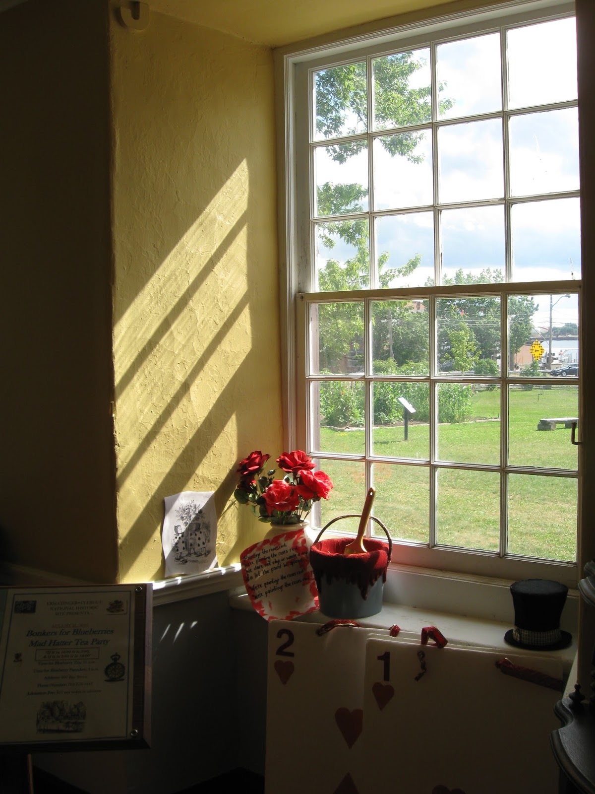
 Through the handsome 12x12 sash, you can get a glimpse of the Sault Ste. Marie waterfront. What sights have been seen through these precious panes of glass!

(The rather disconcerting red bucket is part of a Mad Tea Party decor with which the parlour was being cleverly transformed, for a fund-raiser.)

The house was built of local stone and large cedar logs for Charles Oakes Ermatinger, a fur trader, eventually partner and agent for the North West Company, and his wife Mananowe, daughter of an influential Ojibway Chief (likely a good way to smooth business dealings between the two nations.) The couple raised thirteen children.

The house was completed in 1814, and remains the oldest stone building northwest of Toronto.
Hard to imagine how it would have looked to the first nations trappers bringing their furs to trade, or to the voyageurs who transported them to Montreal in their freighter canoes. Even among the 'best people' it likely made quite a stir.

 Understandably, the home became the centre of social, business and political life in the northwest in the early c19.  Interpretive panels upstairs in the house describe the social context.

Ermatinger house welcomed visitors like adventurer Anna Jameson and artist Paul Kane, who in 1845 proclaimed the stone house, then inhabited by the customs officer and "general government factotum" Captain Joseph Wilson,  a "tolerably handsome house."

Charles and his family returned to Montreal in 1828, and other local personalities took their turn at the tea table.  Missionary Reverend William McMurray lived in the house from 1833-38, when the house served as residence, church and school for the Ojibway of the Canadian Sault.

In 1853 it became the Stone House Hotel, and was later used by the sheriff, a judge and his court room, the YMCA as a boarding house and meeting hall, a social club with tea room, dance hall and outdoor cabins in the 1930s. Then there were the apartment years. It's a wonder Ermatinger House survived at all, but in 1964 the City bought the house, and began restoration (somebody deserves an award for that far-sighted move.) In 1970 it was declared a National Historic Site, and has never looked back.

Also on the property is the Clergue Blockhouse. Unfortunately, we arrived too late for more than a breathless overview by this delightful guide, who was not about to let us go without a bit of the story.

There's always a book, yes? Right now, I'm awaiting the arrival of my latest interlibrary loan The Ermatingers: A Nineteenth Century Ojibway-Canadian Family, by W. Brian Stewart. I'm hoping it helps me understand the appeal of this place. It's about the architecture and furnishings, sure, and the lives lived here. It's about the vision of the folks who worked to preserve this piece of history, and about the energy and engagement of the sweet young people working there. But mostly it's that old time travel thing. I'm hoping the book, will help me revisit, to connect to faraway SSM and the faraway beginnings of our nation.

Old Road Trip

 A story idea provided the external motivation. Paul Kirby's well-researched book The Trail of Broken Hearts and my trusty road atlas supplied the guidance. The occasional glimpse of an ancestral roof slowly returning to the rocky soil which spawned it kept me going. In two installments, on Saturday and Monday last week, I travelled the Old Hastings Road, from its beginnings just north of Bannockburn to its junction with the Peterson Road in Maynooth.

Throughout Central and North Hastings counties, along the main corridor, Highway 62, appear occasional invitations to time travel. Just north of Bannockurn, in Bancroft and again in Maynooth, highway signs keep the name Old Hastings Road alive. In other places the current highway follows the original route.

Might be wise to begin with the road report. Many parts of this road are not for the faint of heart. The very start of the colonization road, at Lot 1 in Tudor township, is no longer maintained and not navigable - at least not for Blanche, my trusty Honda FIT. Rather a tribute to the folks who struggled north on this road, when it likely didn't come anywhere close to the condition shown in this photo!

In 1853, the government of the day provided funds to open roads to northern parts of the county for settlement. Surveyors, road builders and land agents went to work and free grants of 50 acres were taken up by immigrants looking for a future.

The rules were simple. First you had to find your grant of a few acres in the impenetrable and endless forest. Then you had four years to clear 12 acres , build a house 18 x 20 feet, and maintain the road past your property. Between 1856 and 1863 1000 hopeful souls travelled the road and took up their claims. Before long, the numbers began to dwindle. Unsurprisingly, optimistic early reports of the soil quality were downgraded over the years. A 1962 report indicated that 12.5 percent of the soil in the region was suited for agriculture. Swamps. Rock. Hills.

Were these immigrants tricked? I understand there was pressure by the logging companies to open the roads for timber harvesting. They also would benefit by any agriculture which would provide them with supplies, as well as a local labour pool.

St. Oswald's Anglican Church (1871)
Across Highway 62 from that remaining southern section of the OHR  is a well-maintained road leading to Millbridge, Glanmire, Thanet, Murphy's Corners and Ormsby.

Millbridge is the first community, heading north on the Old Hastings Road. At one time it bustled with three hotels, mills, stores, a school, a town hall, and a church. Its streets are paved, and many of the old buildings are still inhabited, including St. Oswald's Anglican Church.


Down the road is the cemetery. Cemeteries always survive, even when other traces of living early settlements have long disappeared.

Settler Anna Leveridge wrote her poignant letters home to England from a log cabin just south of Millbrige on the OHR. A trip along the road, even today, makes Your Loving Anna come alive for me.

Millbridge Cemetery
 A white frame two-storey farmhouse on a well-maintained property north of Millbridge suggests that someone was able to remain, and build that second home, after the first years in a log house.

It's conceivable that the lower kitchen wing could have been the original log house. Sometimes these first houses of Upper Canada's settlers were repurposed as sheds or barns, other times incorporated into the second home. Sometimes the more sound ones were clad in planks or even brick, as the family's prosperity grew. John Rempel shows a great example on page 36 in Building With Wood.


The next house is just south of Millbridge. I'm guessing it's a log house, later clad with lumber, now with roughcast, judging from the position of the upstairs windows.


 Things get pretty gloomy in the middle section of this road. Although the hard-packed surface (at least in a dry November) was good, the road travels through deep cedar woods, mostly blind corners and hills, and hardly more than one vehicle wide.


Very little traffic, but the occasional Ford F150 or quad kept us very alert. Few spots to stop for a photo; unfortunate as this section gives a pretty good feel for what it might have been like (but for the reassuring presence of the hydro lines.)


Jelly's Rapids heron
Eleven km. further on, Jelly's Rapids on Beaver Creek was the site of Glanmire (originally called Jelly's Rapids for the first settler in 1856.) Today a picturesque concrete bridge over the fascinating geology of the creek, and the nearby cemetery are all that remain of
hotel, mill, post office, school and church,

For a little geology sidetrip, here's a video shot by some cavers...and I think the rock is basalt, guys.


Glanmire's St. Margaret's Church (1886 - mid 1970s)
Glanmire had a good mill site (not clear on whether a mill materialized), a post office, and was a lively community. Kirby includes descriptions of the OHR version of church lawn fetes in the 1870s to 90s. How important such diversions would have been in the very hard lives lived there.

By 1887 St. Margaret's Church and cemetery were established. By the mid 1970s the church was deconsecrated and demolished. The steps remain.

log house returning to the earth


Thanet is another settlement along the road memorialized by its cemetery, which a group of citizens rescured from oblivion. There are little handmade signs for the genealogist, telling the settlement story in a minimal way.


All that remains of Murphy's Corners is the old gas station. A log house existed until very recently, according to people I've talked to.

The Murphy family left starving Ireland in the years from 1851 to 1859, in stages, as funds permitted. Not sure which side of the ocean would have been more difficult for the Murphys.


Murphy's Corners is the beginning of the last stage before Ormsby - and I use the term 'stage' advisedly, as the Tall Pines Rally uses this challenging technical stretch. (Here's a link to the reason why you don't want to be on this section of the road on November 26th.)


Ormsby, OHR at Highway 620
At the top end of this bendy stretch of OHR, around a final bend through the cedars, past the two churches, the road opens out onto the settlement of Ormsby. More on that lovely spot later, in the voyage along the Old Hastings Road - from Ormsby to Maynooth.

All along the way my thoughts were on the settlers,  Irish and Scottish tenant farmers who were forced by uncaring landowners and famine to take the desperate move to emigrate into this terra incognita, wooed by the opportunity for free land - land of their own, on which to build a future.