Ancestral Roofs

"In Praise of Older Buildings"

Saturday, November 26, 2016

Taken by the Wind

I'll be the first to admit it. I have a problem with architectural history books. I can never pass a used book table without scanning the collected titles for one I don't have. At the regular third Tuesday public presentation of the Hastings County Historical Society recently, I found two. Marilyn Hughes extended me credit to enable me to pack home Taken By the Wind: Vanishing Architecture of the West by Ronald Woodall and T.H.Watkins (General Publishing,Don Mills, 1977.)


I like how Woodall sums up the appeal of old buildings slowly returning to the earth:

Morganstown
   "Abandoned country buildings are monuments to laughter and grief and childbirth and death and the best and the worst of times. More than that, they are beautiful not just because they are old and weathered and picturesque and quaint but also because they embody the spirit of a noble and resourceful lifestyle. There is intrinsic beauty in the functional simplicity and craftsmanship that outlasts the craftsman. There is beauty in timelessness."

During my roadtrip in Northumberland County on autumn's last gentle warm day, I fell under their spell.


Shannonville
 As I have on many other travels through farm country. These travels feed the soul somehow. Just a few hours in the company of fields and woodlots, farm buildings and gentle livestock, creeks and knolls and sky is all it takes.


near Elginburg


These junkets recapture those childhood Sunday drives with dad and mom, we kids admittedly not so enthralled, in the back seat.
Dad pronouncing on farm crops, fences and building, the laudatory and the disparaged. Our dad was a man of strongly held opinions.
Frontenac Co.

Snow Road area
 But we kids would succumb to our gentle mom's diversionary tactics: count the train cars, not long 'til we get to the ice-cream stop with the bear, look at this, look at that.  imagine the stories that old house could tell. That last admonition contributed to a life-long love of our built heritage. as I explained in my very first post back in April 2010.
near Lonsdale
I have been enjoying sifting through my photo files; hope I haven't bored you. Blame it on Woodall and Watkins.

Salmon Point, PEC
Or on Orland French, he of Wallbridge House Publishing, and the creator of three fine historical atlases. Orland asked me to contribute on things architectural in the 2013 publication about Prince Edward County, Wind, Water, Barley and Wine. He figured 200-plus years in the neighbourhood gave me some cred. And he guessed at the depth of my obsession.
Orland especially wanted to highlight early frame building techniques, and I did my best to explain what I found in my photos of split lathe, hand-hewn beams, wooden pegs and home-built mouldings yielded by a close exploration of this lovely old ruin, one of the rare times I ventured onto private property (though whose, goodness only knows.)

Sandon, British Columbia

Although Taken by the Wind is published in Canada, the photographer travelled throughout the Canadian and American west looking for loss. I immediately looked for familiar spots. And found one or two. When we lived in B.C. we explored ghost towns whenever we could. In 2013, when we last visited, we retraced a cold trail to a favourite spot, Sandon. Not just a house, but a whole town, building by historic building,  being taken by the winds of time.

Power House

Sure, you can probably recall one in your neighbourhood. But can you describe it? Kinda blends in with the rest, nothing showy. Never much activity around. Quiet neighbour.

I'm talking about hydro houses. I've been aware of them for years, but never paid much attention. The one I can readily recall in the east end is a nondescript little red brick bungalow. Will have to track down a photo someday soon.
Hadn't given hydro houses any notice, with or without camera until a daytrip to Kingston last week. Striding along Brock street, on one of the sidewalks blessedly clear of ice and snow, I spied this nice Deco house. Front lawn with spruce, unidentified deciduous tree, tidy foundation plantings. Looked inviting, until a closer look  revealed its identity.

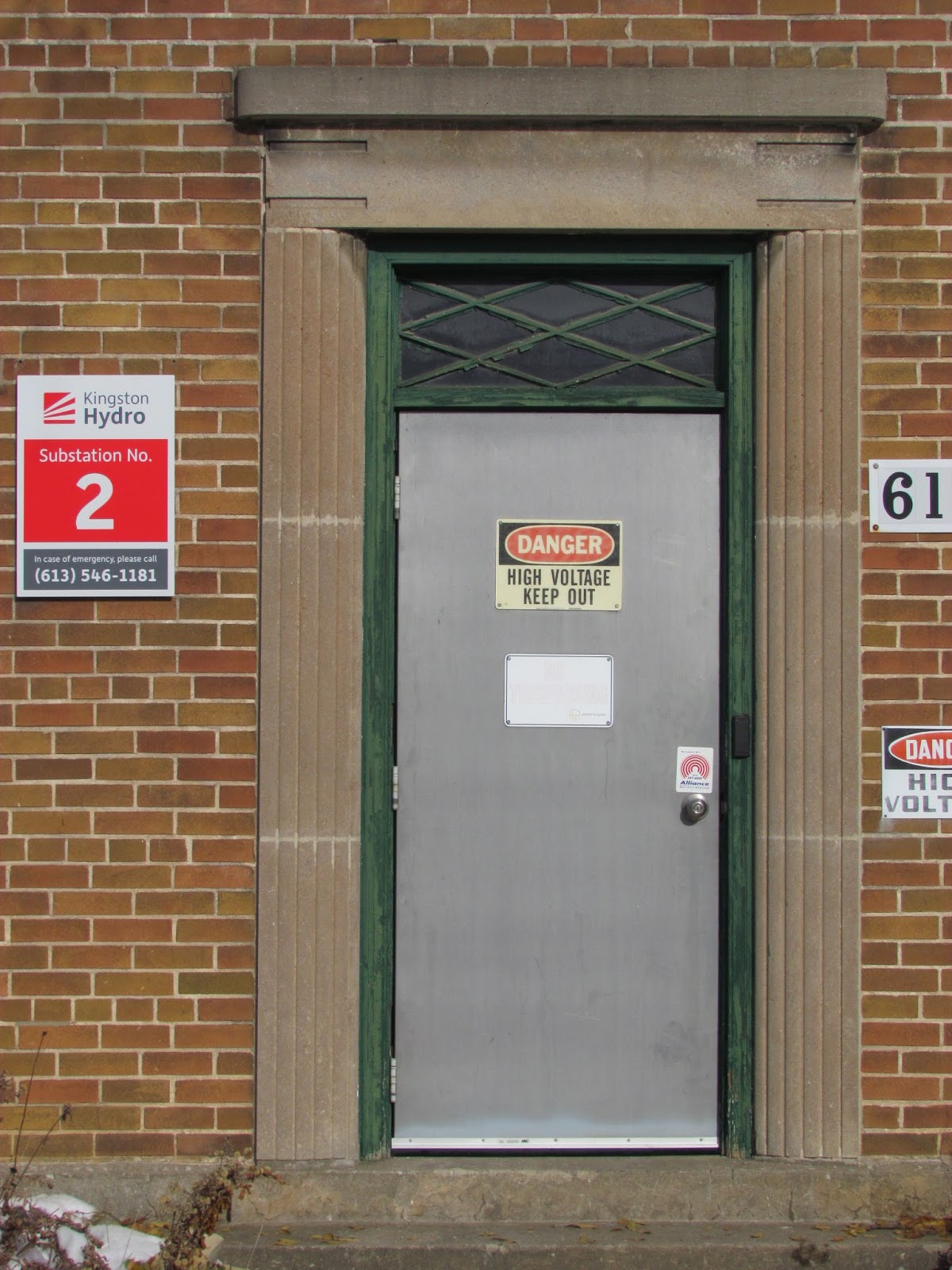
Although the strictly business steel front door was surrounded by a finely moulded Deco frame, the DANGER High Voltage Keep Out put me instantly on the trail.

No notes to the milkman on this homely brick stoop. This is the home of Kingston Hydro Substation No. 2.

Hydro substations convert high voltage electricity from power generation stations to 220 and 240 volt service suitable for domestic use.

An online search revealed several sources with information about hydro houses. All focus on Toronto specimens (of which there are 250 and counting, downward, as they reach end of life and are demolished.) What intrigues me is the architectural diversity among them.

horizontal banding, dentils, tight eaves, flat roof
Photos of these Toronto sites reveal delicious examples of prairie, colonial, victory, cape cod, suburban bungalow, collegiate Gothic, Edwardian classical, modernist and an outrageous Scottish baronial style substation,  as well as a couple of facsimile churches. All designed by nameless architects to blend in with their neighbourhoods.

homey shutters, sash windows
WebUrbanist, from whom I borrowed this post's clever title takes us back to the establishment of the great generators at Niagara Falls in 1911  which necessitated a system of substations in Toronto neighbourhoods. As tony Toronto was unlikely to take to "ugly conglomerations of metal, wire and ceramic resistors" in the 'hood, Toronto Hydro set up an in-house team of architects "to 'clothe' the substations in the fashionable brick, masonry and woodwork of the day", either as fake office or warehouse buildings or fictional grand homes. The article provides a photo tour; have a look at the Scottish baronial Glengrove substation on Yonge Street!
hexagonal window, nicely framed

Understandably, after the depression and the war, the team toned down their urban substations.That would explain the 'plain Jane' on Herchimer Street in the 50s and 60s neighbourhood near us. (I'll record it, and two others in Belleville, on Jones Street (that must be a playground structure to the right, if the principle of camouflage is still at play) and a utilitarian modern structure on Reid Street. My guess is that these neighbourhoods weren't so fussy, or Hydro had just stopped caring.

Here's a link to a Heritage study which provides more than you might ever want to know about a typical residential substation in Windsor. One thing it does, that most of us don't, is to honour this powerful bit of our built heritage.

Here's Blog TO's photo essay, and a 2012 article in The Walrus, if you want to see more. I will certainly be on the lookout in a town near you. Do let me know if you have a Hydro house in your neighbourhood!

This lovely classical building still fits in well with the historic downtown (if you overlook the expanses of parking lot signalling overzealous demolition.) It was built in 1892 as the HQ for the privately owned Kingston Electric Light Company. Today it's a distribution substation for Kingston Hydro.

Thursday, November 24, 2016

Putting on a Brave Face

Had to remind myself not to be cute about this post title.
No 'False Gods' stuff. I just wanted to spend some time researching the history of this eye-catching church on Johnston Street in Kingston.

There's no much online about the structure. The name also intrigued; fortunately that information was available. The Dormition of the Theotokos (theological words for the death or "falling asleep" of Mary, the Mother of God, and her resurrection and assumption into heaven) . There, I'm way out of my depth here, so I'll leave it at that.

As you can see, a pretty important event in the Greek Orthodox church, and a logical choice for a church name.


The architecture is eye-catching: an Italianate design, with the characteristic tall round headed windows. The classical pediment, some dentils and modillions, a parapet, arched portico, the triple Palladian style windows in the frontispiece are classical in origin,  The polychromatic brickwork (my companion observed the later repairs using different bricks) creates quoins and window hoods, and pilasters up the sides.

But here's the thing. Viewed from the front (and likely the interior, if the richness of the Greek Orthodox tradition of decoration lives here) the church is a pretty impressive.

The Ontario Heritage Trust inventory reports that construction was begun in 1881, by a denomination not specified. Looks like the Greek Orthodox church is a more recent inhabitant of the structure, and cannot be held responsible for the architecture.

 I don't want to cast aspersions on any house of worship, but a sidelong glance can be disconcerting. A look (askance) from the side reveals the truth - a rectangular hall with a gable roof and (hate to say it) a false front.


Isn't that (and a good haircut) worth the drive to Kingston, Brenda?


Did he really say bastardized?

One of my favourite history websites (and the most prolific one I know) is the meticulously researched Marmora Historical Foundation site, renewed almost daily by the dedicated local historians Anne and Andre Philpot.

Georgian proportions, Hastings
Today's post really hit home, on a subject which causes me pain on occasion. It's the story of the large red brick Georgian house at
# 3 Forsyth Street in Marmora.  Here's the best look I can offer you; thanks Streetview. The post highlights the evolution of former fine homes into businesses, with frontages which certainly don't respect, and in most cases, totally obliterate, the formal proportions and hand-fashioned detail of early homes.

In the case of today's post, the Philpots relate the transformation of an 1868 Georgian home in Marmora to commercial and office uses. And yes, he really said that.

I don't find too many of these metamorphoses in my photo files, as I find them painful to look at, and challenging to record. I know. I know. I fully accept that old houses standing on former quiet residential streets-become-busy-downtowns will not survive intact over the years.  I also acknowledge the decline that time creates.
Kingston

And admittedly, many c19 homes weren't separated from business areas; in fact many housed the family shop on the same premises.


Loss is inevitable. But we still can grieve.

Thanks for grieving with us, Philpots.

Newburgh

Group of Ruins

Pic Island, real and as imagined by L.Harris

An article Den has just read reports the sale of  Lawren Harris' Mountain Forms for 9.5 million dollars, and observes that Canadian painting (of all eras one hopes) is on the ascendancy in Europe. Actor/art collector Steve Martin has recently ensured that thinking Americans know Lawren Harris and his artist associates.  If the group of painter-adventurers had not already had the last laugh, this unprecedented sale price would make up for all that "hot mush" invective they had to endure when they were the newest and most challenging painters about.
Den's cautious look around the next turn, bear air horn in hand


The announcement of the sale has me thinking about the time we spent in Lawren Harris' company on Lake Superior this summer. For surely his spirit is on the great lake, as it was on him.


The Group of Seven and their unique vision for Canadian art has been memorialized throughout the Algoma and Lake Superior regions in a series of roadside (and beachside) interpretative installations. These take the form of easels (with a handy seat) supporting a panel with a print of a Gof7painting inspired by the location, and lots of other images and information. More here.
R.W.Coldwell's grave


Den's lodestone is Pic Island. Harris' well-known painting of the island was displayed (along with the real thing) at the top of our 9km. return hike through bear country, in Neys Provincial Park, where we lived well for a week in August.

courtesy Neys PP visitor centre


At the outstanding Neys PP Visitor Centre, we learned about another location which drew some of the artists, the ghost town of Port Coldwell.

courtesy Neys PP visitor centre


A search for resonance, as I call it, and perhaps signs of the life of the former fishing village which began in 1883, led us over the railway tracks and down a winding overgrown road to the cove.


The village centre was up the hill, alongside the tracks. Coldwell was named for R.W. Coldwell, a Scot who supervised the blasting crew laying foundations for the CPR track struggling to impose itself onto Superior's resistant shore.

Astonishingly, Coldwell is buried in the little Port Coldwell cemetery (ironically, the only sign of life there.) Coldwell loved the place, and the folks loved him. Villagers bestowed his name on their village, and later, Coldwell asked for his remains to be returned from Scotland to be buried there.

By 1915, thanks to the dual economic engines of commercial fishing and the railway, the village had 135 inhabitants,  and a general store, church and school.

 In not the first time environmental issues have changed our fortunes, the improvement of shipping lanes in the Great Lakes system (eg. Welland Canal) led to the incursion of the sea lamprey, which destroyed much of Lake Superior's commerical fishing stocks.

By 1960, the Port Coldwell fishery was dead, and by 1963, with the new Highway 17 taking shoppers further afield, the general store closed, and the village slowly died.

My photos of two of the Visitor Centre displays show the village as it once was.

These photos recorded a hot day in August 2016.

Incidentally, on another note entirely, but pertaining to significant buildings lost to history, Neys Provincial Park is the former site of a WWII POW camp, hosting Nazi officers. Here's a good account of this little-known chapter in our history. For a more in-depth study, join Den in reading The Little Third Reich on Lake Superior (University of Alberta Press, 2015.) Available at Belleville Public Library (once he's finished.)
courtesy Neys PP visitor centre

Tuesday, November 22, 2016

Onward and Upward

OHR meets Co.Rd. 620 at the OHT plaque
Upward, in map-speak, is further north.
And this is where I intend to take you.


Last week I posted about my journey to Ormsby along the Old Hastings Road (or what remains of it) and the vanished or vanishing villages along its twisty route - Milldbridge, Glanmire, Thanet.

 Ormsby is an exception, a vibrant spot along the OHR. Doomed to ghost town status by folks like Ron Brown, Ormsby is doing very well, thank you very much, all credit to the dedication, hard work, and vision of the Pattisons. It's quite remarkable really. I have written about them on AncestralRoofs, and in the Spring 2012 issue of Country Roads magazine. Check out their website.

I first met this delightful family in 2012. Shortly after that, Denis and I visited the tea room.

featured in Fall 2016 ACORN

Logging and the railway created a bustling community in the late 1800s; their demise led to the near-death experience of the village. Only the store keepers, the Parks family held their ground, operating the store until 1975.

It's that very store that today is home to the enormously popular Old Hastings Mercantile and Gallery. Owners Lillian Oakley Pattison and Gary Pattison (quite interesting folks, do go meet them) bought the empty store and made magic. They are also behind the reopening of Ormsby's Presbyterian church as the Old Ormsby Heritage Church, which hosts wonderful anniversary and Christmas services. Gary's twin brother Ernie and his wife Debbie restored the village schoolhouse, and have created another popular stopping place, the Old Ormsby Schoolhouse Tearoom. It takes people like the Pattisons to raise a village.

 Ormsby is certainly a bright spot on the dark road, and sorry history of the Old Hastings Colonization Road.

North of the village (population: 20) the road is no less curvy or hilly (there's one very interesting right angle turn/steep hill combination) but as Lillian and Gary assured me "it's a school-bus route." I think it truly was wider that the previous section, and very well graded. No comforting guard-rails however, so there were a few corners providing mouth-drying views to the forest floor well below.

The Wollaston township scenic route sign identified this stretch as Homestead Hills. Unfortunately, due to the need to keep eyes (and Blanche) on the road, I saw little evidence of homesteads. Will do the stretch again with my co-driver who is better at finding parking in dubious places.
 Just before the point where the OHR rejoins today's Highway 62 south of L'Amable (and, I'm guessing, where it begins to follow the same route) is the entrance to the old Irish settlement of Umphraville; its post office operated from 1864 to 1916. This road was definitely a four-wheeler track, and Blanche talked me out of trying it. It was the beginning of hunting season, another good reason not to be bashing about in the woods. The Spring 2012 issue of Country Roads magazine tells the story of the Umphraville Cemetery, and the folks who tend it. The cemetery is just about all that remains of an 1850s village which once offered a second slim chance to many "surplus tenants" on Irish estates, who had been forced off their small holdings and onto immigrant ships (6000 from one estate alone!) during the potato crop failures of the 1840s and 50s.

L'Amable, Bancroft. Onward and upward.

Just south of Maynooth, the OHR reasserts itself, in a short side-trip over a hill and down into the town. This thriving village with its unique general store, a farmer's market and a lively arts community. was called a variety of names as it grew - Tara, Oxenden, Doyle's Corner. Maynooth was among the latest spots along the OHR to be settled. Once again, the settlers were mostly displaced Irish.

I'll leave the next stage of the journey to another time. For it is at Bancroft and again at Maynooth that the colonization road story branches out in a different direction, onto the east-west lying Monck and Peterson Roads.

For a much more detailed trip along the Old Hastings Road, and the family stories written there, pick up a copy of Paul Kirby's painstakingly researched book The Trail of Broken Hearts (Kirby Books, 2014.)

Monday, November 21, 2016

The Battle of Hastings

Road trip. Warm sunny November day. The last in a series. Road-tripping in the Trent Hills. I picked up a takeaway lunch and enjoyed it on a park bench on Front Street, admiring reflections in the millpond-smooth Trent River. I watched some fellows demolishing an old house. And I worried a bit, because I recalled two Queen Anne houses along this stretch of road. And neither was anywhere to be seen.


I even accosted a friendly dog-walker, who kindly directed me to a number of older homes he appreciated in his regular visits to the village.

But Lee couldn't recall the pair of over-dressed Victorians I was wondering about. I was determined that those houses stood along the river!


I drove around town, and in short order, I discovered my two painted ladies. Where they always stood, on Bridge Street South.

 What this turned out to be, was the mind playing tricks. The battle of Hastings.

I leave Tom Cruickshank to say something sensible to rescue this post from silliness. In Old Ontario Houses (Firefly Books, 2000) he describes the twins as "dazzling essays in Queen Anne exuberance," listing the "profusion of stained glass windows, spoolwork trim and fish-scale shingles...cone-roofed towers, bay windows and..tiered verandahs."


They are called the Doxcee houses, built c1900 by a local lumber merchant, from plans drafted by an architect from New York. Cruickshank relates that the plans were found in the attic of the yellow house while it was being restored.


They look like Victorian summer cottages, although I insist they would be much nicer situated along the river.


They remind me of a pair of almost identical Queen Anne summer homes in Wellington, which I had a look at a few springs ago. These two look like the same plan, reversed, though one risks whip-lash by trying to compare details.


And these two stand on Main Street screened behind majestic old trees, with a view of the lake (although a bit compromised by later builds) recalling the days when Wellington was a breezy resort community far away from the bustle.